Wetland ecosystem condition and river connectivity were the focus for environmental water management in the Intersecting Streams catchment in 2023–24.
Key outcomes
Under moderate conditions, environmental water managers worked with partner agencies to coordinate the protection of water for the environment in the Intersecting Streams catchment to:
- help sustain waterbird breeding habitat and vegetation condition at Narran Lakes
- improve system connectivity between the Condamine–Balonne rivers and the connected Culgoa–Birrie–Bokhara–Narran system
- inundate the western floodplain to the Darling floodplain at Toorale National Park and State Conservation Area
- provide connection between the Warrego and Darling rivers
- inundate significant areas of wetlands along the Paroo River.
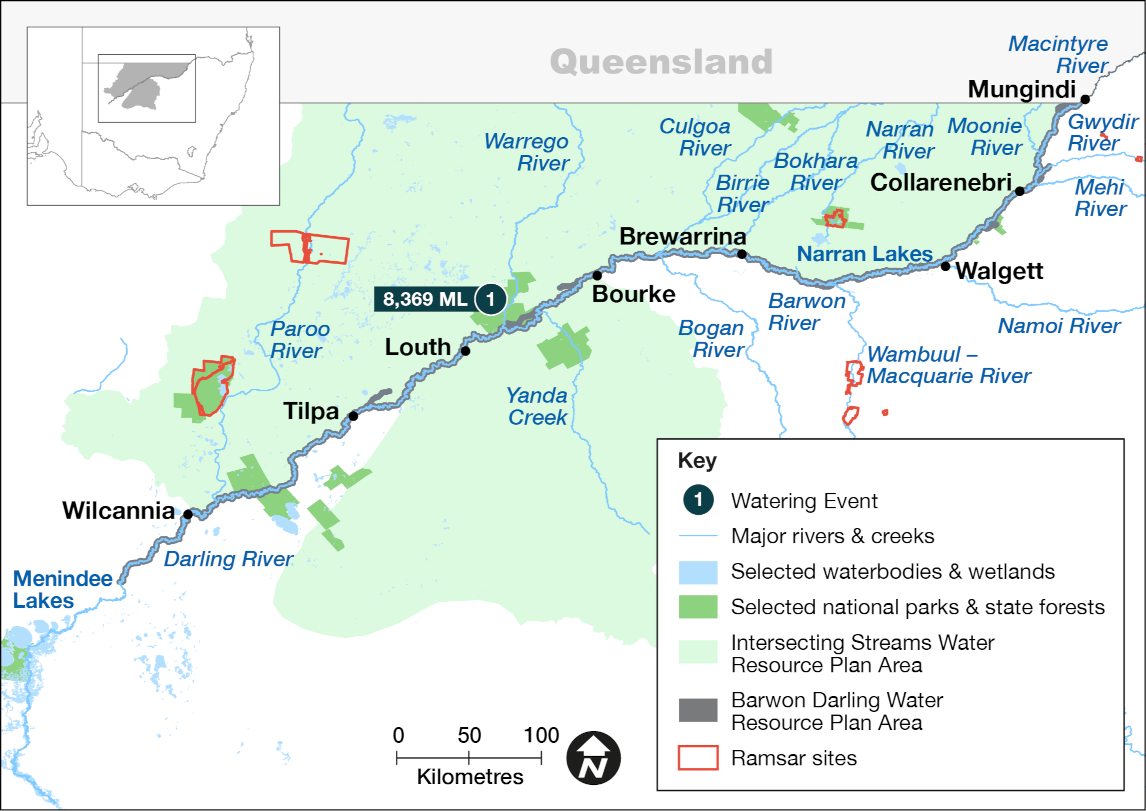
Map of the Intersecting Streams catchment showing the location of a water for the environment delivery made in the 2023-24 water year with corresponding volume.
Catchment conditions
During the first half of the 2023–24 water year, the Intersecting Streams catchment experienced below average rainfall over winter and spring. Conditions were relatively warm and dry and resulted in few small flows.
This turned in November 2023, with rainfall at or above average for the remainder of the water year. This created a series of flow events over summer 2023–24 and autumn 2024 in the Paroo and Warrego rivers and the connected Culgoa–Birrie–Bokhara–Narran system.
Partnering with Aboriginal peoples
Water for Country is environmental water use planned by the Department of Climate Change, Energy, the Environment and Water and Aboriginal people to achieve shared benefits for the environment and cultural places, values and/or interests.
In the 2023–24 water year in the Intersecting Streams, environmental water managers:
- supported Kurnu-Baarkandji Nation planning for the Toorale Cultural Watering Plan
- continued to build relationships with the Toorale Joint Management Committee through meetings on Country and conversations about the update of the Intersecting Streams Long-Term Water Plan with cultural values and interests
- worked with members Kurnu-Baarkandji to map ecological and cultural features on the western floodplain.
Watering aims
The Annual environmental water priorities in the Intersecting Streams catchment 2023–24 were developed under expected moderate weather and water availability.
Objectives for the use of water for the environment were to:
- support stocks of native fish and provide opportunities for them to breed and disperse into secure habitats
- increase the duration of inundation of water-dependent vegetation at Narran Lakes
- increase the duration of inundation of water-dependent vegetation on the western floodplain at Toorale
- ensure adequate vegetation condition and water levels, should further inflows trigger a colonial waterbird breeding event at Narran Lakes in spring 2023.
With moderate to wet conditions, water managers used plans devised at the start of the water year.
Water delivery
This table and chart provide a summary of 8,369.5 megalitres (ML) of water for the environment delivered to water the western floodplain at Toorale, in the Intersecting Streams catchment during the 2023–24 watering year.
The Commonwealth Environmental Water Holder coordinated the protection of 92,754 ML of water for the environment in Queensland, from the Warrego (14,456 ML), Nebine (1,328 ML), Moonie (5,671 ML) rivers and Condamine–Balonne system (71,299 ML). These flows contributed to environmental outcomes across parts of the NSW Intersecting Streams and into the Barwon–Darling River.
Figures were accurate at the date of publishing but may be adjusted. The watering event number in the table and bar chart relate to the location number marked on the map.
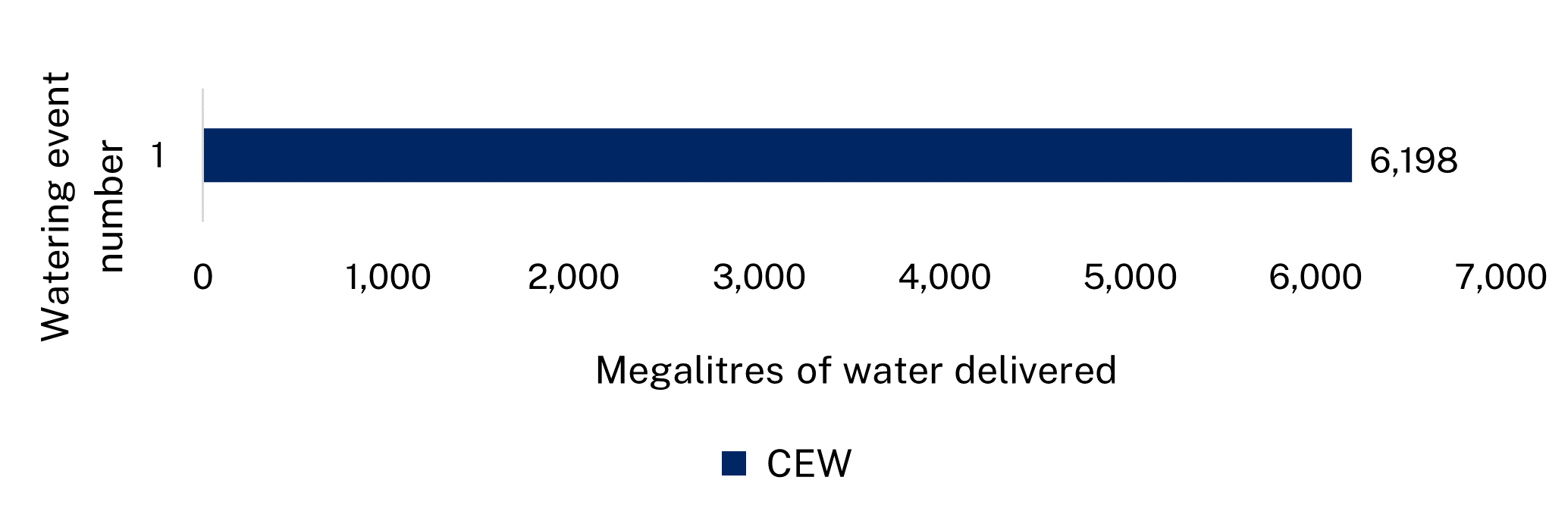
Water delivery to the Intersecting Streams catchment in the 2023-24 water year.
Notes: CEW = Commonwealth licensed environmental water.
| Water event number | Event name | Outcomes | Start date | Finish date |
|---|---|---|---|---|
| 1 | Western floodplain wetlands flow | Native vegetation, waterbirds, native fish | 23 January 2024 | 30 June 2024 |
Outcomes
In the 2023–24 water year, much of the Intersecting Streams catchment received small and large fresh events that were protected in part by Commonwealth environmental water licenses through Queensland into New South Wales.
The Commonwealth protected 71,299 megalitres of environmental water in the Lower Balonne, which contributed to flow events in the connected Culgoa–Birrie–Bokhara–Narran system.
This supported:
- vegetation condition at Narran Lakes
- native fish movement and recruitment
- lateral and longitudinal system connectivity.
Management of Warrego River flows at Toorale saw inundation of a large area of the western floodplain and connection with the Darling River from the Warrego main channel from early 2024.
NSW-funded fish monitoring on the western floodplain found spangled perch, Hyrtl’s tandan, bony bream and juvenile golden perch.
Flows from the Warrego River also entered the Cuttaburra Channel inundating a large area of wetland in the Yantabulla Swamp.
Rainfall in south-western Queensland and north-western NSW resulted in significant flows through the Paroo River system and inundation of wetlands at Nocoleche Nature Reserve and Paroo–Darling National Park during summer.
The Commonwealth also protected water in Queensland, 5,671 megalitres in Moonie River and 1,328 megalitres in Nebine Creek, which contributed to flows in the Barwon–Darling River.
Case study: Western floodplain flourishes with flows
Rainfall occurred across much of the Warrego catchment in January and flows commenced down the system triggering an event under the Toorale Operations and Maintenance Plan. Initial flows were passed through Boera Dam until connection was achieved with the Darling River. A portion of inflows was then directed to the western floodplain, while maintaining downstream connection with the Darling River.
Flows to the western floodplain continued until the end of the water year, with a large event in April and May which saw a peak of over 200,000 megalitres per day at the gauge near Charleville in Queensland. The event from January to the end of the water year saw a total of 11.47 gigalitres pass to the western floodplain, with 8.3 gigalitres accounted for by Commonwealth licensed environmental water. This inundated some of the wetlands of the western floodplain.
Fish surveys have identified several native fish species using the upper part of the western floodplain, including yellowbelly (golden perch), Hyrtl’s tandan, spangled perch and bony bream. Of the 197 fish caught, only 3 carp were recorded which is considered unusually low for this pest species in our western rivers. Large numbers of waterbirds, including brolgas, a state listed threatened species, were seen foraging in the open waters and dense vegetation of the western floodplain.
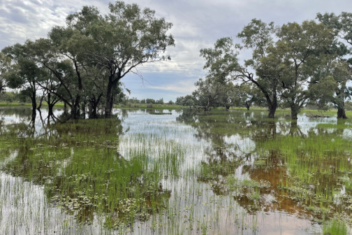
Western floodplain