Water that is allocated and managed specifically to improve the health of rivers, wetlands and floodplains is known as water for the environment.
NSW environmental water management teams work with local community advisory groups including landholders, Aboriginal stakeholders, partner agencies and other interested community members to develop detailed annual plans for the use of water for the environment in each catchment, including how its use is prioritised.
Water for rivers and wetlands
The Department of Climate Change, Energy, the Environment and Water (the department) worked with the Snowy Advisory Committee and ecological experts to design releases for the Snowy and montane rivers. Daily releases are planned from May 2024 through to April 2025. This will include:
- applying ‘natural flow scaling’ approaches for the Snowy and upper Murrumbidgee rivers
- releases for the Snowy and upper Murrumbidgee rivers with higher flow rates over winter, spring, and early summer to reflect flow patterns typical of mixed rainfall and snowmelt river systems
- a series of high flows and 5 events with 8-hour peaks in the Snowy River to help mobilise sediment
- providing 3 flow peaks to the upper Murrumbidgee River to support native fish, move sediment, encourage productivity and reduce vegetation encroachment within the river channel
- trialling flow flexibility for the Snowy and upper Murrumbidgee rivers for the first time in response to natural cues such as rainfall events.
During 2023–24, the department worked with Snowy Hydro to deliver 220,556 megalitres (ML) of Snowy River Increased Flows and 92,800 ML of Snowy Montane Rivers Increased Flows to the Snowy and montane rivers.
Partnering with Aboriginal peoples
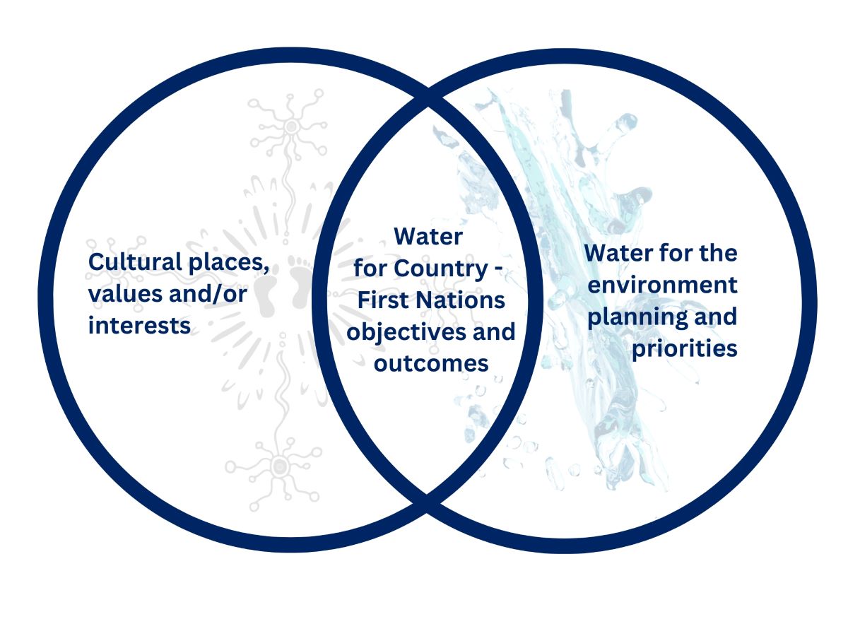
Water for Country is environmental water use planned by the department with Aboriginal peoples to achieve shared benefits for the environment and cultural places, values and/or interests.

Environmental water managers have been working to support Aboriginal people’s priorities in water management.
The department and Snowy Advisory Committee will continue to partner with Aboriginal people to embed cultural knowledge and values into the Snowy and montane water for the environment program. In 2024–25 we plan to:
- recognise the priorities of Aboriginal people from Ngunnawal, Gunaikurnai, Wolgalu and Ngarigo locally and regionally, to increase understanding of cultural values in the Snowy and montane rivers
- work with the Snowy Advisory Committee to implement Aboriginal priorities with respectful relationships that mutually inform the use of water for the environment
- ensure the Snowy Advisory Committee discussions are inclusive, and support the priorities of Aboriginal representatives from Ngunnawal, Wolgalu, Gunaikurnai and Ngarigo.
Weather and water forecast
As of April 2024, the El Niño–Southern Oscillation has returned to neutral conditions and is expected to remain neutral until at least July 2024. There is a 40% chance the median rainfall will be exceeded during winter.
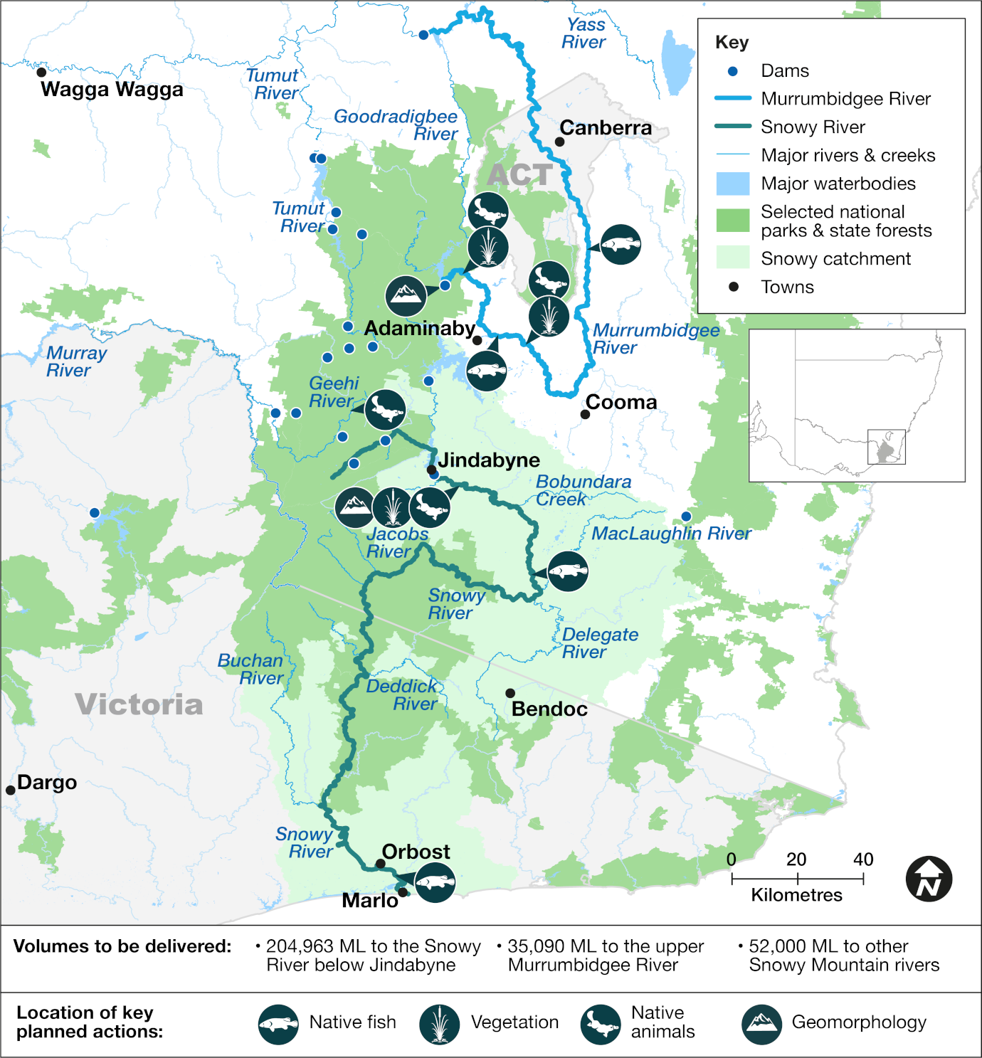
The near-average rainfall conditions of the previous year provided 204,963 ML of water for the environment for the Snowy River in the 2024–25 water year. A foregone electricity generation of 139 gigawatt hours (GWh) is available for the Snowy montane streams, which is the equivalent of 52,000 ML for the Snowy montane streams and 35,090 ML for the upper Murrumbidgee River.
There is sufficient allocation to deliver environmental water to all the targeted Snowy montane streams. Water is delivered to these streams by closing the aqueducts designed to divert water to storage dams, allowing water to overtop the weirs and continue to flow freely.
Under an adaptive management plan, water managers have prepared daily flow patterns based on known water availability, that consider the forecast weather scenario. This is known as resource availability scenario planning.
Resource availability scenario
This table provides details about how we plan for different resource availability scenarios. Moderate conditions are forecast for the Snowy and Snowy montane rivers in 2024–25, which means water availability planning will follow the ‘moderate’ scenario.
Current forecast: Moderate
| Conditions | Main aim | Other aims |
|---|---|---|
| Very dry | Protect | Avoid critical loss Maintain key refuges Avoid catastrophic events |
| Dry | Maintain | Maintain river functioning Maintain key functions of high priority wetlands |
| Moderate | Recover | Improve ecological health and resilience Improve opportunities for plants and animals to breed, move and thrive |
| Wet to very wet | Enhance | Restore key floodplain and wetland linkages Enhance opportunities for plants and animals to breed, move and thrive |
Key planned actions for 2024–25
Native fish
Flows will be delivered to support native fish breeding and dispersal in the Snowy and Snowy montane rivers. Small autumn pulses in the Snowy River will support dispersal and spawning of the threatened Australian grayling.
Higher releases in winter and spring to the upper Murrumbidgee River will encourage spawning and movement for the endangered Macquarie perch. The upper Murrumbidgee supports 1 of only 3 remaining natural populations of the perch species in New South Wales.
Vegetation
Releases will promote recruitment of aquatic native vegetation in low benches, connected ponds, wetlands, and backwaters that support water-dependent animals, such as platypus and frogs. Multiple high releases into the Snowy and Murrumbidgee rivers will also help limit the encroachment of terrestrial plants in the riverbed.
Native animals
Planned releases will support a diversity of habitats for water-dependent animals, including macroinvertebrates, frogs, platypus and turtles. This will increase resource availability and productivity and provide opportunities for breeding and recruitment. Inundation of connected wetlands and ponds will provide breeding opportunities for frog species.
Geomorphology
Planned flows aim to improve Snowy River channel condition by providing multiple high flows including 5 events with 8-hour peaks. These high-flow events will increase stream power (flow velocity) to flush fine sediment from the stream bed, reduce algae smothering and clean riffles.
Map of proposed annual priority targets in the water resource plan area 2024–25

Map of the Snowy and montane rivers catchment area showing priority targets for environmental water to be delivered to in 2024-25, and the volumes.
The department supports the health and resilience of alpine and subalpine rivers by delivering water for the environment to the Snowy and Snowy montane rivers. We use the best available science, management expertise and experience to manage environmental water across the landscape. This statement of annual priorities identifies the planned releases for waterways.
Our decision-making process considers:
- availability of water in the coming year
- daily releases and conditions of the previous year
- current health of native plants and animals in these ecosystems.
The Snowy Advisory Committee provides feedback and advice to the department on the timing and pattern of releases of water for the environment
Water for the environment is a share of the water in dams and rivers that is set aside to support the long-term health of local rivers, creeks and wetlands. Healthy rivers carry water to homes, farms, schools and businesses. Rivers and wetlands are important cultural and spiritual sites for Aboriginal people, as well as the broader community.
Table 1 Summary of annual water allocation availability for the Snowy River for 2024–25
| Water account | Annual volume (ML) |
|---|---|
| Snowy River increased flows | 196,463 |
| Base passing flow – Jindabyne | 8,500 |
| Under delivery use | TBC |
| Total | 204,963 |
Table 2 Snowy montane rivers increased flows allocations and settings for the 2024–25 water year
| River reach/catchment | Modified works | Conversion factor (GWh per 1,000 ML) | Forgone electricity generation (GWh) | 2024–25 volume (GL) |
|---|---|---|---|---|
| Murrumbidgee River | Tantangara Dam outlet | 1.94 | 68.1 | 35,090 |
| Goodradigbee River | Goodradigbee River Weir | 1.94 | 13.6 | 7,000 |
| Geehi River | Middle Creek Weir | 1.95 | 32.4 | 17,500 |
| Geehi River | Strzelecki Creek Weir | 1.85 | 9.6 | 5,200 |
| Snowy River – Island Bend to Lake Jindabyne | Tolbar Creek Weir | 0.71 | 6.7 | 9,500 |
| Snowy River – Island Bend to Lake Jindabyne | Diggers Creek Weir | 0.71 | 6.7 | 9,400 |
| Snowy River – Guthega to Island Bend | Falls Creek Weir | 0.57 | 1.9 | 3,400 |
| Total | – | – | 139.007 | 87,090 |
Notes: GL = gigalitres; GWh = gigawatt hours; ML = megalitre. 2.5 megalitres = 1 Olympic swimming pool.
This is an indicative summary of expected volumes to be available. For further detail and information on available volumes, please contact the region by phoning Department of Climate Change, Energy, the Environment and Water enquiries on 1300 361 967.

The NSW portion of the Snowy catchment area is 9,070 square kilometres.