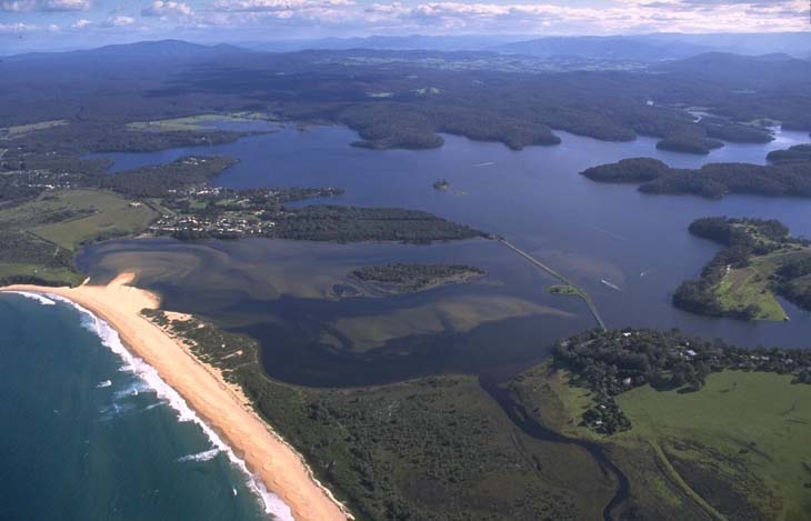
Wallaga Lake is located north of the township of Bermagui on the south coast of New South Wales. It is classed as a lake with an intermittently closed entrance.
Dignams Creek and Narira Creek are 2 major tributaries that feed into the lake. The lake supports great biodiversity, including seagrass beds, swamps, saltmarsh and wetlands.
Wallaga Lake is a popular tourist destination as it provides a host of recreational activities in a well-preserved environment. The lake is commercially fished for finfish, prawns and oysters, providing one of the largest commercial catches on the south coast. Meads Bay is a significant area within the estuary as it is a fish nursery.
Water quality report card
As part of our water quality monitoring program we assess the water quality and ecosystem health of an estuary using a range of relevant indicators. We sample a subset of the estuaries between Wollongong and the Victorian border every 3 years. The most recent sampling in Wallaga Lake was completed over the 2021–22 summer, when 3 sites were sampled on a monthly basis.
This report card represents 2 water quality indicators that we routinely measure: the amount of algae present and water clarity. Low levels of these 2 indicators equate with good water quality.
Algae
Water clarity
Overall grade
We have monitored water quality in Wallaga Lake since 2008. This table shows the water quality grades for this estuary over that time.
| Year | Algae | Water clarity | Overall grade |
|---|---|---|---|
| 2008–09 | C | A | B |
| 2017–18 | C | B | B |
| 2020–21 | B | A | B |
Physical characteristics
| Estuary type | Lake |
|---|---|
| Latitude (ºS) | –36.37 |
| Longitude (ºE) | 150.08 |
| Catchment area (km2) | 263.8 |
| Estuary area (km2) | 9.3 |
| Estuary volume (ML) | 33,512 |
| Average depth (m) | 3.7 |
Tidal exchange volume
Tidal exchange volume or tidal prism data is available for this estuary. This data was recorded in 1995.
| Tide state | Flow (ML) | Local tidal range (m) | Sydney Harbour tidal range (m) |
|---|---|---|---|
| Ebb flow | 400 | 0.05 | 1.35 |
| Flood flow | 380 | 0.03 | 1.31 |
Notes: km2 = square kilometres; m = metres; m3 = cubic metres; ML = megalitres.
Water depth and survey data
Bathymetric and coastal topography data for this estuary are available in our data portal.
Land use
The catchment of Wallaga Lake is moderately disturbed. About 35% of land has been cleared for grazing in the Tilba Tilba and Cobargo region. Over half of the catchment is forested, with substantial portions in Gulaga and Kooraban national parks.
National and marine parks
- Kooraban National Park is the largest conservation area in the Wallaga Lake catchment.
- Gulaga National Park is a significant cultural area for the Yuin people in this catchment and is jointly managed by Aboriginal owners and the NPWS.
- The estuary flows into the Batemans Marine Park.
Citizen science projects
- The Far South Coast Conservation Management Network supports the local community to manage and recover biodiversity and organises citizen science projects, a local plant database and events.
Community involvement
- Bega River and Wetlands Landcare Group is a volunteer organisation focused on the Bega River and floodplain wetlands.
- The Far South Coast Landcare Association is a volunteer community-based conservation group.

Aerial view of Wallaga Lake estuary.
Local government management
Local councils manage estuaries within their area unless the estuary is attached to a marine park.
Bega Valley Shire Council manage this estuary, which is located in Batemans Marine Park.
Threatened species
Over 60 bird species rely on the Wallaga Lake ecosystem for breeding, shelter and food. The lake is a significant little tern breeding area.
Koalas and long-nosed potoroo are also found in conservation areas of the Wallaga Lake catchment.
Find out more about the biodiversity in our estuaries.