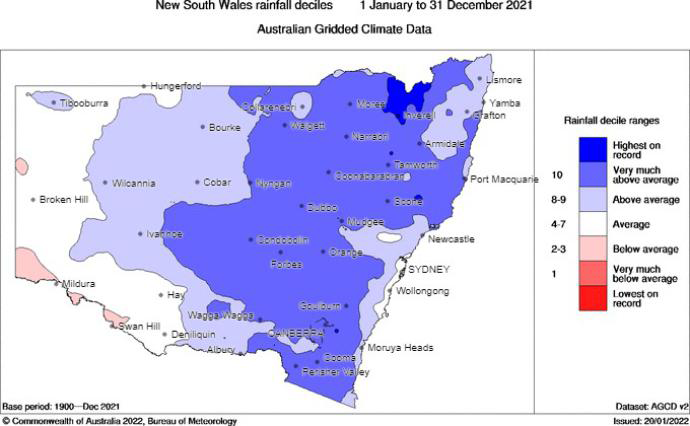
The Bureau of Meteorology reported that, in 2021, New South Wales experienced its sixth wettest year on record, with rainfall 30% above average. It was also the coolest year since 1996, with temperatures only 0.15°C above the long-term climate average.
The wet and cool conditions in New South Wales in 2021 would have contributed to the improved air quality experienced across the state, by reducing the frequency and intensity of dust storms, bushfires and wind erosion events. Winter minimum temperatures were warmer than average, reducing smoky nights in regional areas from domestic wood heaters.

Rainfall decile ranges for 1 January to 31 December 2021.
Summer 2020–21 in New South Wales was wet and cool. New South Wales saw 29% more rainfall than the 1961–90 climate average, and daytime temperatures were below average for much of the state, making it the wettest and coolest summer since 2011–12 at 0.03°C above the 1961–90 average. A significant rainfall event occurred in the state's northeast in December 2020, with much of the region recording their wettest conditions since national records began in 1900.
Autumn 2021 in New South Wales started with very wet conditions, with the state seeing the second wettest March on record with rainfall 155% above the 1961–90 climate average. A low-pressure system off northwest Australia, in combination with a blocking high pressure system in the Tasman Sea, resulted in an extreme multi-day rainfall and flooding event which affected most of New South Wales between 17 and 26 March 2021. The following months of April and May were much drier, with below average rainfall for most of the state except some coastal regions, including the South Coast. New South Wales recorded cooler than average days and nights in autumn, with average temperatures 0.54°C below the 1961–90 average.
Winter 2021 was wetter and warmer than average in New South Wales. Mean maximum and mean minimum temperatures were warmer than average, and mean winter temperatures were 0.93°C above the 1961–90 average, equal to the tenth warmest winter on record. Rainfall totals in New South Wales were 14% higher than the 1961–90 climate average, with significant rain falling on the west of the Great Dividing Range, especially in the Central and Northern Tablelands.
Spring 2021 was the fourth wettest spring recorded since national records began in 1900, wettest since 2010 and with 69% higher rainfall compared to the 1961–90 climate average. Thunderstorms and heavy rainfall contributed to areas recording their highest spring rainfall on record or at least in the last 20 years. Spring was relatively cool, with average temperatures more than 1°C cooler than most years in the last decade, though 0.17°C above the 1961–90 average.
December 2021 was wet and cool along the coast. Rainfall was above average on the coast and northern NSW but was below average in some areas inland of the Dividing Range. Daytime temperatures were generally below average along the coast but were warmer inland. Mean December temperatures were 0.34°C above the 1961–90 average.